- Producers of typical products
- Forum
- Environmental Education
- The Authorities
- Organization and Offices
- Council Notice Board
- Transparent Administration
- Reference Legislation
- Regulations in force
- The plan of the Park
- Consultation of deliberative acts


The island of Pantelleria represents the emerging tip of a volcanic complex of which about 28% has emerged, while the remaining 72% is located below sea level, up to a depth of about 1200 m. The birth of the volcano is linked to the formation of a large area of distensive in the Strait of Sicily with NO-SE trend. This "rifting" has been active since the Late Miocene and accompanied by widespread volcanic activity mainly concentrated in the NW area of the Strait of Sicily.

 Download KMZ
 Pantelleria is a real active volcanic complex: the last episode of eruptive activity, a submarine eruption, occurred in 1891 at 5 Km on the north-west with respect to the Port of Pantelleria, showing that the primary volcanic activity is located in the submerged portion of the volcanic complex.
The process of formation of the island can be schematically divided into three periods: from 320,000 to 180,000 years ago; 180,000 to 45,000 years ago; 45,000 to 7,000 ago. The latter period began with the deposition of the "Green Tuff" and ended with the pouring of the Khaggiár spilling from the eruptive center of Kúddia Randázzo. To date, volcanism in the emerged sector is manifested by secondary activities: marine geothermal sources, natural cave saunas, fumaroles, terrestrial geothermal sources in Lake Venus.
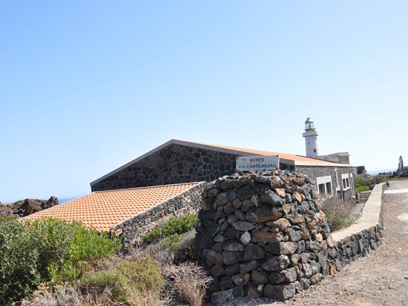
The geovulcanological itinerary is an entirely carriageable thematic route designed to observe some of the phenomena of secondary volcanism present on the island: it starts from the Sataria Caves, natural caves originated by differential erosion between the pumice (easily eroded) and the lava flow above ( resistant to erosion), inside which springs of hot water at a temperature of about 40 °C flow into three tanks. The quality of the thermal waters of this cave is evidenced by the origin of the name Sataría, which derives from the Greek "Soterìa" and means "cave of health". The itinerary continues going up to the crossroads of Grazia, reaching the Bukkuràm district and the Grotta del Freddo, where it is possible to experience hypogeum microclimate phenomena. From Bukkuràm, passing through the district of Sibà, you reach the intersection with the pedestrian path that leads to the quiescent eruptive center of Kúddia Mida (path no. 972). Returning along the driveway you cross the innermost areas of the island, with a privileged view of some of the main kúddie, valleys and ridges that characterize its morphology, until you reach the lake: the "Lago di Venere", a large caldera up to 12 meters deep and located about 2 meters above sea level. The lake offers hot springs, in which the water reaches a variable temperature between 40 and 50 °C, and natural mud. From the lake, take the perimeter road and cross an important lava formation, the Khaggiar lavas, inside which the Volcanological Museum is located near the sea. The last stop is Cala Gadir, a small marina that houses many thermal baths, already present during the Roman period, where you can also dive in the evening.