- Producers of typical products
- Forum
- Environmental Education
- The Authorities
- Organization and Offices
- Council Notice Board
- Transparent Administration
- Reference Legislation
- Regulations in force
- The plan of the Park
- Consultation of deliberative acts
The first area of considerable interest is the area of Mursía and Çimillía, archaeological sites of considerable value due to the presence of the prehistoric village (with Muro Alto) and the area of sési, probably Neolithic tombs built by the first known inhabitants of the island, dating back in the Bronze Age.
After passing Punta Fram, where the lunar landscape bears witness to the eruption of the kúddia of Gelkhamar, and the seaside resort of Suváki, the coast rises and hides at the sea level the Cave of Sataría or Satería, inside which there are thermal water pools made during the Roman domination.
The coast returns low and extends southwards to meet the Harbour of Scauri. Beyond it, there are Skálo and Calette di Scauri, where recent archaeological research has shed light on a naturalistically and historically important area. In addition to being a spa, they represent the Phoenician harbour, while their inner part includes warehouses for foodstuffs and more. In a large cave at the end of the cove area, there are several points where hot water comes out, evident manifestations of the island's volcanic activity.
After this area, Dietro l'Isola begins, with its high cliffs, often inaccessible, all facing south. At first Niká, with its thermal waters and small harbour, shelter for small boats. But the greatest attraction is certainly Salto La Vecchia, a cliff that rises up to 242 mt above sea level. The Dietro l'Isola journey continues; the road climbs more and more, leaning against the Kúddia Attalóra and crossing Baláta dei Turchi, Punta Limársi, Martingána and the Dietro l'Isola sea stack.
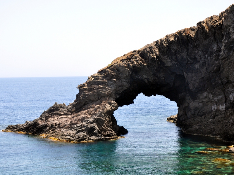
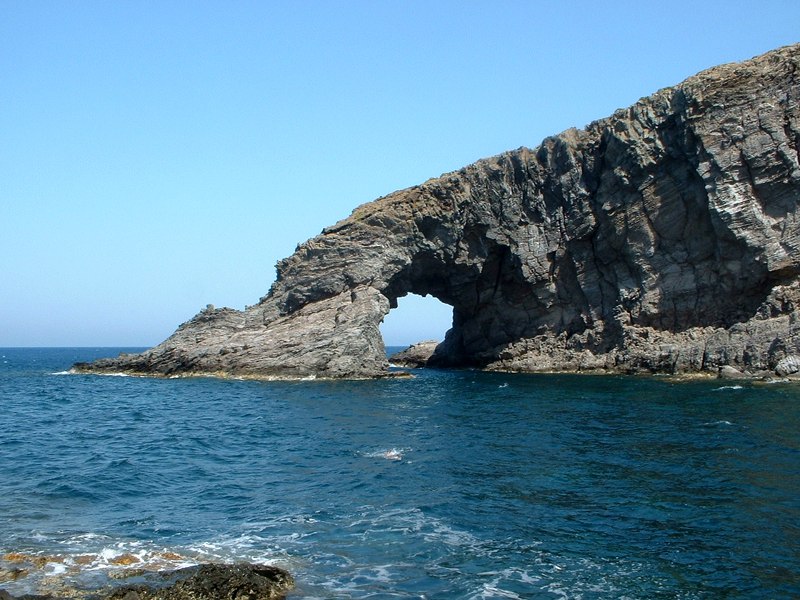
Dietro l'Isola ends with Makasinázzi and Arco dell'Elefante, a real natural monument that stands as a symbol of the island. Here are located two of the most beautiful coves on the island, Cala Levante and Cala Tramontana, and the coastal stretch begins, leading from south-east to the north-west. The perimeter remains high and meets Gadír, a small port that houses many thermal baths, always built during the Roman period, as well as a vast underwater archaeological area.
From here we reach the area of Cala Cottóne, Punta Spadillo and Cala Cinque Denti, a large impervious area, dominated by the Mediterranean scrub in its most significant meaning, the holm oak. The whole area is dominated by the Khaggiár, a vast lava flow originating from the eruption of nearby Kúddia Randazzo. To mention in this characteristically wild content the presence of Laghetto delle Ondine, a wide and shallow depression of the coast which forms a sort of natural pool with a high landscape value.
After Cala Cinque Denti the perimeter suddenly drops down to meet Khattibuáli, a very fertile land that separates the sea from the Specchio di Venere Lake, and bounded to the north by Punta Pozzolana, where a fort was dug in the cliff during the Second World War. From here you could return to the northern area of the island.